TransCAD 5.0

Allows you to store, display, manage, and analyze transportation data
4 
Rating
Your vote:
Latest version:
4.8.385 See all
Developer:
Screenshots
1 / 1
Awards (1)
Show all awards
Recommended by Software Informer award
Download

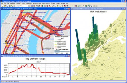
TransCAD is the first and only Geographic Information System (GIS) designed specifically for use by transportation professionals to store, display, manage, and analyze transportation data. TransCAD combines GIS and transportation modeling capabilities in a single integrated platform, providing capabilities that are unmatched by any other package.

TransCAD has applications for all types of transportation data and for all modes of transportation, and is ideal for building transportation information and decision support systems. TransCAD runs on readily-available hardware under Microsoft Windows and embraces virtually all desktop computing standards.

Comments

5 stars
13
4 stars
2
3 stars
2
2 stars
3
1 stars
2
User

Your vote:

Related software

CAD Viewer
CAD Viewer
rating

View, print and convert CAD files.

Any DWG to PDF Converter Pro
rating

It's a batch converter that allows you to convert DWG to PDF.

VeryPDF PDF to DWG Converter
rating

This tool lets you convert a PDF to DWG or DXF with a lot of ease.

OverCAD PDF TO DWG
OverCAD PDF TO DWG
rating

Application that allows you convert PDF to DWG.

CAD Markup
CAD Markup
rating

Add AutoCAD markup and PDF markup capabilities to CAD Viewer 2016.

Related suggestions

Transcad 4.5 full